Why does Hawaii have volcanoes in the middle of a tectonic plate?
Why does Hawaii have volcanoes far from plate boundaries? Explore the Hawaiian hotspot, Pacific Plate motion, and island ages with a simple map exercise.
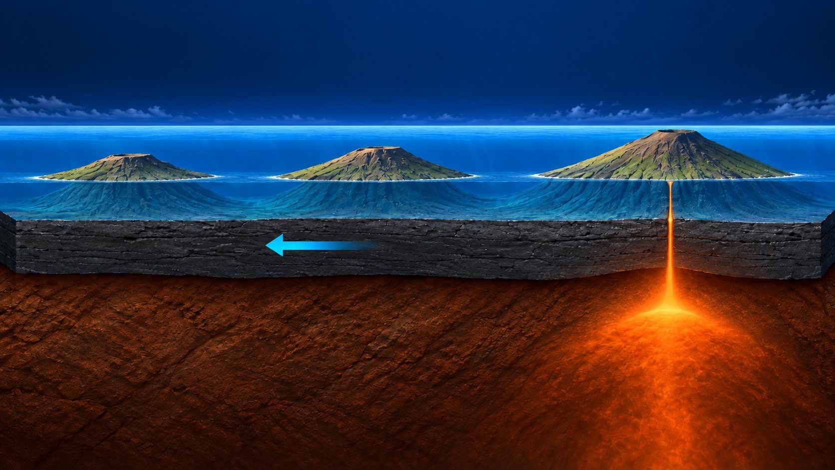
Many volcanoes stand where tectonic plates meet or pull apart. Hawaii seems to break that pattern: its islands lie inside the Pacific Plate, far from a plate boundary. The hotspot model explains why. Hot mantle material rising beneath the moving plate supports volcanism over long periods. The plate carries the volcanoes away, while younger ones develop above the magma-supplying region.
That combination builds a chain rather than a single island. Read the direction of the chain alongside the ages of its main volcanic structures, and you can begin to see a history of plate motion.
An island is not necessarily a separate plate
Hawaii sits on the same large Pacific Plate as the surrounding ocean floor. The island chain does not mark a seam between two neighboring plates.
Volcanism at many plate boundaries results from different geological processes. Hawaii is an example of intraplate volcanism: volcanic activity within a plate. For a comparison, see the guide to three basic plate boundary types. Here, the useful question is not “Which two plates collide?” but “How does this plate move relative to its magma source?”
What is the Hawaiian hotspot?
In this setting, a hotspot is a long-lived region of volcanism associated with hot material rising from Earth’s mantle. In the widely used mantle plume model, unusually hot rock rises and can generate melt. Magma travels upward and, if it erupts at the surface, becomes lava. The mantle is not simply an underground ocean of liquid lava.
For the chain, relative motion is what matters. The Pacific Plate travels over the region supplying volcanism. A simple model treats the hotspot as relatively fixed, not as a point that has remained absolutely motionless throughout Earth’s history. The USGS summary of Hawaiian geology uses that distinction too.
Building an island from the seafloor
Growth begins underwater. Repeated additions of volcanic material build a volcano upward from the seafloor. If the structure reaches and rises above sea level, a volcanic island emerges. The land we see is only the upper part of a much larger structure.
Broad shield volcanoes are central to this story. Their name describes their gently domed shape. An island can consist of several overlapping volcanic structures: the island of Hawaiʻi is not one enormous volcanic cone. The National Park Service’s hotspot explanation illustrates how a moving plate can carry successive volcanoes away from their source region.
The island does not then float independently across the ocean. Its foundation moves with the plate beneath it.
Why are the main volcanoes older toward the northwest?
Around Hawaii, the broad direction of Pacific Plate motion is northwestward. A volcano that formed above the hotspot moves away from the most productive magma supply. Younger volcanic structures can develop farther southeast. Over geological time, this produces a spatial sequence of different stages.
Four familiar islands make useful reference points:
| Along the chain | What to notice |
|---|---|
| Hawaiʻi in the southeast | The younger end of the main high islands, with young volcanic structures |
| Maui | A next reference point toward the northwest |
| Oʻahu | Farther northwest, with older main volcanic structures |
| Kauaʻi | Farther northwest again; its main volcanic structures are much older than those of Hawaiʻi |
These are not exact island “birthdays.” An island’s age is not the age of every lava flow on it. Volcanoes grow over long, overlapping periods, and some experience smaller renewed phases after lengthy pauses. The USGS account of Hawaiian volcano growth and degradation explains why the age progression of the shields differs from the history of every individual eruption.
What happens to older islands?
As magma supply declines, processes that reshape the volcanic structure become increasingly important. Rain and rivers cut valleys, waves attack coastlines, and large landslides can remove parts of a volcano. Long-term subsidence also contributes. The geological trail therefore includes submerged volcanic mountains as well as high islands.
This is not a clockwork sequence in which every island disappears after the same interval. Growth, erosion, landslides, and changes in elevation interact. Deeply eroded scenery can fit a long history, but a vacation photograph cannot give you a precise rock age.
A four-step map exercise
- Find the whole island group. Start with the North Pacific rather than a single crater.
- Locate Hawaiʻi and Kauaʻi. Check the map’s orientation: Hawaiʻi lies southeast of Kauaʻi.
- Compare the plate boundaries. Use a geological plate map to see that the chain lies inside the Pacific Plate, not along its edge.
- Add the time dimension. Connect the independently established ages of the main volcanic structures with northwestward plate motion. The map itself does not date rocks.
Imagine a slowly moving base carrying volcanic structures away from a limited supply region. Younger structures grow above that region while earlier ones move onward. You do not need a separate hotspot for each island to explain the chain.
Explore the spatial picture with LiveGlobe 3D
In LiveGlobe 3D, you can rotate and zoom the globe, search for Hawaii using the magnifying glass, and enable the plate layer in the settings. Begin far enough out to see the island group’s Pacific setting, then move closer. Bring the age information from your geological source into the comparison.
The web app requires sign-in, and place search relies on an external service. Additional live-event layers depend on data availability and, in some cases, Premium access. Spatial orientation and a geological map are enough for this exercise.
Explore the views available to you in LiveGlobe 3D with one question in mind: What does the arrangement of these islands reveal about motion over millions of years?
Two common questions
Does each island need its own hotspot?
No. The basic model explains a chain through plate motion: older volcanic structures travel onward while younger ones develop above the supply region. Nor is there a strict rule of one volcano per island.
Is the hotspot completely stationary?
No. “Relatively fixed” is a useful simplification, not a claim of absolute immobility. The geometry and evolution of the magma source are more complex than a single fixed point beneath a perfectly smooth plate.
Short clips
The app in motion: short, genuine glimpses straight from use.
At a glance
How the app feels on your phone.